 EMODnet Product Catalogue
University of Algarve (UAlg-FCT)- Centre of Marine Sciences (CCMAR)
Type of resources
Available actions
Topics
Keywords
Contact for the resource
Provided by
Years
Formats
Representation types
Update frequencies
status
Scale 1:
-
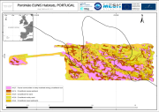
The Algarve coast presents a significant portion of territory that is part of the designated National Nature Reserve, in its underwater slope (0 to 30m depth - RENSUB), especially when compared with the equivalent on land. The current digital map presents the EUNIS habitat of the central Algarve RENSUB coast. The covered area is between Ponta Piedade and Barra do Ancão. The sediment classification was obtained through the interpretation of data from Side Scan Sonar (remote-sensing image), while for the habitat mapping the biological sampling was carried out with beam trawl and underwater visual census.
-
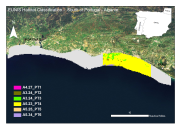
Under the MeshAtlantic project (2010-2013) the habitat of an area offshore Portimão (south coast of Portugal) was classified. The biological data was gathered from surveys carried out during 2012. Stratified sampling by depth and bottom substrate was performed using Van Veen grab and beam trawl to estimate fauna densities. Additional and significant data was obtained from image analysis of video records collected during Remote Operated Vehicle (ROV) surveys carried out under the UALG/CCMAR programme. Both these surveys began with a previous acoustic mapping of the seabed by means of Side Scan Sonar and Multi-beam, followed by sediment type classification and ground truthing validation using Van Veen grab sampling.
-
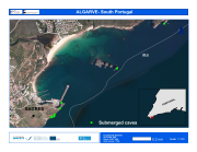
Under the MeshAtlantic project (2010-2013) the habitat of an area off the south coast of Portugal (Sagres) was classified. The biological data from the caves habitat was gathered from surveys carried out during 2012 and 2013. Sampling was performed using underwater visual census and Video transect along the cave. Historical data were also analised.
-
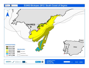
Under the MeshAtlantic project (2010-2013) the habitat of an area off the south coast of Portugal (Sagres) was classified. The biological data was gathered from surveys carried out during 2012. Stratified sampling by depth and bottom substrate was performed using underwater visual census, Van Veen grab and beam trawl to estimate fauna densities and quadrate method to estimate macroalgae coverage. Additional and significant data was obtained from image analysis of video records collected during Remote Operated Vehicle (ROV) surveys carried out under the UALG/CCMAR programme or from strict cooperation with the NGO OCEANA. Both these surveys began with a previous acoustic mapping of the seabed by means of Side Scan Sonar and Multi-beam, followed by sediment type classification and ground truthing validation using Van Veen grab sampling.
-
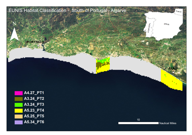
The Algarve coast presents a significant portion of territory that is part of the designated National Nature Reserve, in its underwater slope (0 to 30m depth - RENSUB), especially when compared with the equivalent on land. The current digital map presents the EUNIS habitat of the central Algarve RENSUB coast. The covered area is between Albufeira and Vale do Lobo. The sediment classification was obtained through the interpretation of data from Side Scan Sonar (remote-sensing image), while for the habitat mapping the biological sampling was carried out with beam trawl and underwater visual census.
-
Marine communities of the coast of Fuerteventura .
-

Marine communities of the coast of Almeria .
-

Marine communities of the coast of El Hierro .
-
The Algarve coast presents a significant portion of territory that is part of the designated National Nature Reserve, in its underwater slope (0 to 30m depth - RENSUB), especially when compared with the equivalent on land. The current digital map presents the EUNIS habitat of the central Algarve RENSUB coast. The covered area is between Gal├® and Barra do Anc├úo. The sediment classification was obtained through the interpretation of data from Side Scan Sonar (remote-sensing image), while for the habitat mapping the biological sampling was carried out with beam trawl and underwater visual census.
-
Marine communities of the coast of La Gomera .